Could we see 25°C AND snow this week?

Short answer: Yes. For the longer answer, continue reading.

No matter which one you are or are not excited for, remember two things: 1. For both, it is more likely it won’t happen then it will, and 2. For both, the probability of it happening it is far from a 0% chance.

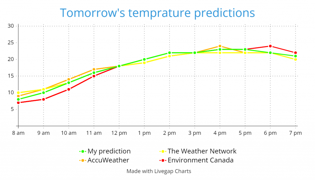
Starting off with the 25, I would say the most likely day that we’ll get it is tomorrow. The forecasts are currently saying 22 for The Weather Network, and 24 for Environment Canada and AccuWeather. Currently I’d say it’s going to be a high of 23 or 24. but still there’s a good change at having a 25. For more info, check out the chart below.

Now for the snow. This one is a little more compllicated. The lows of the forecast is sort of favouring a cold low for Friday night. Right now, maybe 3 or so? All I need is The Weather Network to get at least 3 degrees lower, and then I’ll be much more certain. You might be thinking: “3? That’s not enough for snow at all!” The thing is, we don’t actually need freezing temperatures for snow. If the temperature cools down quickly enough as you go up in the atmosphere, and we have something like 15 km/h winds which continue or even get stronger higher up, and there is instability in the atmosphere, you can actually get snowfall a few degrees above 0. All of those things are currently on the forecast, so all we need is some precipitation at the right time, and we might get probably not complete snow, but a mix of rain and snow, or even something like snow grains.

It seems like this week is shaping up to be very interesting, so keep looking at your email and this website for the latest forecasts.

Posted in Forecast, Precipitation, Temperature | Leave a comment

[Archive] We’ve broken a heat record already – could we see another one?

[Posted Sep 6, 2024]

Today’s record high was 31.1. Was.

At about 4 pm, (right when I started that little forecast of yours) the temperature officially broke through the 31.1 barrier, making today the first, and probably not last, day of September with a record-breaking high.

This heat is looking like it will continue for the next 2 days, with the most likely highs being 30 for both. Tomorrow, the record high is 32.2, est. 2017. That will probably keep going for at least another year (I’m hoping many), because I would say there is about a 10% chance of a high above 32. Sunday is where it’s really going to happen, with the record high being a mere 30.3, all the way back in 1981. 70% chance I’d say.

On the last post about this heat wave, I actually was thinking there might be another record on Monday. This is very not the case anymore, since the temperature plummet is looking like it will happen much earlier and faster than expected back then. This plummet could see us dive from a likely record-breaking high on Sunday to maybe even 5 degrees below average on Wednesday. More on that in a post I’ll send this weekend. (Unless if something comes up, of course)

[2 views as of Sep 16, 2024]

Posted in Archive | Leave a comment

[Archive] Record breaking highs possible over the weekend as temperatures climb towards the 30s

[Posted Sep 4, 2024]

El Niño is having one last big push, where it looks like this final major heat wave of the year might give us one or possibly, but unlikely, two record-setting highs.

Tomorrow the high is looking like it’s going to land in the mid 20s, so definitely no record.

On Friday, the high is looking like it going to land at 27-32, most likely 29. The record high is 31.1, so there’s about a 20% chance that we get a record.

For Saturday, it’s looking like 26-31 for the high, most likely 29 or 30. The record high is 32.2, so it’s very unlikely that we’ll get a new record.

Sunday is looking like our best chance for a record. The high is probably going to be at 26-32, most likely 29 or 30. The record high is 30.3, which leaves us with about a 40% chance.

On Monday, the range for the high is looking much lower, specifically 29-32, most likely 30. The record high is a blistering 32.9, so probably no record.

Finally, for Tuesday it’s looking like a high of 25-28, most likely 27, so once again a low chance of a record.

Overall, Friday and Saturday look like the most likely days for record-setting highs. Keep an eye on your email for the latest forecasts!

[4 views, 1 like as of Sep 16, 2024]

Posted in Archive | Leave a comment

[Archive] September temperature outlook – Here’s what to expect

[Posted Sep 1, 2024]

September’s forecast is starting to shape up to be very interesting. It looks like we may begin 10 degrees above average, and end 10 degrees below. Here’s the forecast:

We are starting off the month with a massive 31 degree high tomorrow caused by a strong ridge in the jet stream. Normal temperatures will come back quickly, but temporarily, with a high possibly below 20 on Wednesday. The warmth will come back soon with another heat wave beginning around Friday, which could, but probably won’t, give us another high in the 30s. The heat wave is expected to slowly erode all through the weekend and into next week. It is hard to tell when it’s going to end right now, but at the moment I’m placing it in the second half of next week.

The second half of the month is looking basically the opposite of the first half. We’ll start it off with some low temperatures around the 16th. The actual lowest high for that cold wave is really dependent on when the heat wave ends. If it ends late next week, then about 15. If it ends mid next week, there’s a chance of our first below 10 high. After that, it’s looking like there might be a mini heat wave around the 20th, which will probably be the last 20 degree temperature of the year, before a big cold wave. This cold wave is looking pretty long-term at the moment, with the possibility of November-like highs and maybe even snow near the end of the month.

Get ready everyone, because Fall is about to come.

[1 view as of Sep 16, 2024]

Posted in Archive | Leave a comment

[Archive] Back to school: Here’s what to expect

[Posted Aug 28, 2024]

School is starting back up! This year the first two school days are a really odd Thursday and Friday before a long weekend. Doesn’t make much sense, but I can still forecast the weather for it!

Currently, our little low that has been producing some cool temperatures and rainy conditions has just recently broke off from the main jet stream flow, making a cut-off low. Hay, that rhymed! This should mean we should transition to partly cloudy soon, because that is the usual condition northwest of a cut-off low, which is where we are right now. The thing is, by the time the weather can actually catch up to what it wants to be, the low is going to have moved off enough that we just clear straight to no clouds tonight.

On Thursday, a high pressure ridge that will develop tonight will start to bump up the jet stream around the Rockies. This pattern is actually a very common thing in El Niño, and it is indirectly caused by that little trouble-making low over the Gulf of Alaska making a return. The mini-ridge will actually warm the temperatures a few degrees above average, meaning the temperature might feel more early August-y, rather than late. Currently the high is looking like something near 23. For the wind on Thursday, it’ll flow off the Rockies and towards Hudson Bay from the high pressure ridge, as it usually likes to do. All this wind will actually make it be pretty breezy tomorrow, meaning the feels like temperature will be near average values. Finally, for the clouds, it’s looking sunny with some cirriforms here or there.

For Friday, It’s looking almost completely the same as Thursday, so, just like before, you can expect a high near 23, with somewhat breezy winds. The only difference is the clouds, where it’s looking like we’ll have higher cloud cover, since there might be a couple bits of scattered Cumulus and Altocumulus among the remaining cirriforms from Thursday. Just a note, the temperature does look more likely to land above 23 than below, but that’s still not for sure.

[6 views as of Sep 16, 2024]

Posted in Archive | Leave a comment

[Archive] Extreme temperature, precipitation, and wind expected to blast through on Tuesday and Wednesday

[Posted Aug 26, 2024]

Get ready everyone! Another cold wave is on the horizon.

To start the explanation off, I’m going to lay out the current conditions, as always. Right now the systems that are effecting us are a high that is in Saskatchewan, a low over Hudson Bay, and finally a low pressure “complex” (as I like to call it) over the area of western NT – YK – northern BC – off the southern coast of Alaska. If you happen to know about blocking patterns, or you just watch The Weather Network a lot, you definitely now know that I’m about to write down some stuff about an omega block. If you don’t know what that is, the next paragraph should fill you in.

“Wave patterns” are patterns of the jet stream and pressure isolines that indicate specific weather conditions in areas relative to them. An “omega block” is a type of blocking pattern, which is a category of wave patterns. Blocking patterns are just wave patterns that are very organized, and don’t let any other systems through. An omega block occurs when the jet stream comes in from west, goes below a low, wraps up and around a high, before going straight back down to another low. In the area near the high, there are warm and dry conditions. In the areas near the lows, there are cool and wet conditions. Omega blocks usually take a while to break up, meaning they can bring devastating droughts a few hundred kilometres away from devastating floods. Great.

At the moment, we are right on the western edge of the high pressure area, meaning above average temperatures, but not super above average temperatures. Since the high is moving off pretty quickly to the east, tomorrow will be much more average. The interesting stuff begins tonight, when the little low over the Gulf of Alaska attempts to cross the mountains, but it just can’t do it. Therefore, it’s squeezed in by surrounding highs, before dissipating. The upper-level trough needs a new host, so it grabs on to the low up in the Northwest Territories, and “troughs” it down to northern and central Alberta, before strengthening it very fast. We could already see the troughing begin this morning!

It will really start to get going Tomorrow afternoon and evening, when the rapidly-strengthening low will stir up the atmosphere enough for some thunderstorms. Those will eventually move off, leading the way for some very heavy rain and possibly flash flooding overnight. The rain will continue until sometime on Wednesday. Wednesday will be very special for other reasons, because it is the day when the low passes right over us. This means a very cold high, and very strong winds and gusts.

Here are my predictions for the overall weather:

Tonight: Clear with a couple of clouds, and a low of 13 or 14. Gentle winds, with gusts of 40 possible.

Tomorrow: Clouds slowly shrouding more of the sky, eventually leaving us overcast. A thunderstorm or two in the mid to late afternoon with showers afterward. A cool high in the low 20s, with a gentle breeze.

Tomorrow night: Light rain in the evening, with a possible lingering thunderstorm, giving way to strong winds and gusts paired with periods of heavy rain and possible localized flash flooding overnight. Low near 10, feeling like 5.

Wednesday day: Rain tapering off with possible gale-force gusts and a high in the mid to high teens, possibly much lower though.

Wednesday night: Winds calming and clouds parting with a low near 10.

[0 views as of Sep 16, 2024]

Posted in Archive | Leave a comment

[Archive] A cold wave is beginning, and it’ll stay for the weekend

[Posted Aug 16, 2024]

The cold has come, and generally it looks like it will bring low 20 highs for today and the weekend. This post is mainly going to be just for the reason why we’re getting the cold.

At this very moment we are sort of in the middle of the polar and equatorial jet streams. The polar is just a few hundred kilometres north, while the equatorial is in the central US. Generally when this pattern occurs, we’ll get near average temperatures. We are looking like few degrees below, though, and that would be all from the rain. Usually when rain falls it’ll make the temperature rise much slower than normal, so lower highs. If we were going to be dry, we would probably be getting highs more like 22-25.

The reason that we’re getting all the cold and rain is a sneaky little low that formed recently over southern BC. It managed to split the entire jet stream in two, making the polar and equatorial jet streams, and it also sent out an army of troughs into the surrounding area, exploding the couple clouds we had last night into a full on overcast-with-light-rain Nimbostratus.

The reason we are going to keep getting rain all through the weekend is the low, of course. It’s staying put, sending out trough after trough keeping the prairie Nimbostratus alive even through the whole time the jet stream is pulling it away at lightning speed off to Hudson Bay. Eventually, something like Sunday night or Monday morning, a high will push up the jet stream enough that it blocks the low from making any more troughs. This ridge is actually going to be part of an omega block, meaning we’ll get hot real fast on Monday.

Overall for the weekend, expect highs in the low 20s, with some showers at times, sunny breaks at others, and possible thundershowers in the afternoons/evenings.

[0 views as of Sep 16, 2024]

Posted in Archive | Leave a comment

[Archive] An overview of August – What’s happened and what’s to come

[Posted Aug 15, 2024]

We’re halfway through August already! It’s the month when we start getting fed that first taste of Fall, though no falling yet. That’s a September thing.

For the wind, you would usually expect this month to be when we get some gusty winds and cooler breezes. In this first half of August though, it really hasn’t been too windy or gusty, with only 4 days with some actual winds that could make the forecast “Breezy”. Those days are the 3rd, 4th, 10th, and 14th, if you were wondering.

For the precipitation, it’s been dry, not bone dry, but water vapor dry. The only significant precipitation has been in our mini cold wave of the 3rd and 4th, were we got a total of 26.8 mm of rain on the two days, with the most on the 3rd.

For the temperature, so far we’re cooler than July, with the average temperature being 19.6, instead of 22. I think it is very probable that that will go down as we keep going through the month, as it looks like weaker heat waves and at least two more cold waves are coming up, while the first half had only one cold wave and stronger heat waves. I think we will end up at 19 or maybe 18 for the final result.

Overall in the past 15 days, it’s been a fight between two sides for temperature, with warmth on the first 3 days and the last week, and cold anywhere in between. The lowest high and low so far are 18.4 and 11.2, which actually happened three days apart, with the high on the 5th and the low on the 8th. The highest high and low were even more apart, with the highest high a mere 3 days ago, when we almost reached 30, only 3 fifths of a degree away, while the highest low was achieved near the start of the month with a low of 17.7, on the 2nd.

For the smoke, it’s not been too bad at all except for yesterday and today of course. On the first week, we had some very good air quality, with the averages hanging around 30. The second week was still okay, with averages near 60, but Wednesday was bad, with 127. Early this week has actually brought an improvement, with the averages going down to about 50. The only really bad stuff has been yesterday and today, with the averages in the 200s, with the worst being today.

Finally, for the forecast, it’s looking like sort of the same stuff. Two heat waves, and one or two cold waves. There is an interesting trend though, this was not even showing yesterday by the way, it looks like after a few warm days at the start of next week, we might actually end up with near to below average temperatures for the rest of the month. So far, after the cold wave we’re about to get, the next cold wave looks like the 21st – 25th, though that is still uncertain, and another is possible around the 30th. That is really hard to tell at the moment, but if it happens, and if it gets strong, we could see a 2-week long cold wave for mid next week all the way through the rest of the month. That is very hard to tell right now, so at the moment it is covered by a lot of question marks. I will make sure I get a post out when I know for certain when and how long were getting the cold wave.

[3 views as of Sep 16, 2024]
Posted in Archive | Leave a comment

[Archive] The complete records of July 2024

[Posted Aug 13, 2024]

This is the previously-promised complete records of July 2024. There were no more daily records, so this will just be the second table.

Record2021Winner2024 (so far)
MDA* 2521202121
MDA* 2616202420
MDA* 2715202417
MDA* 2814202415
MDA* 2910202414
MDA* 307202410
MDA* 317202410
MDA* 32320248
MDA* 33120247
MDA* 34120244
MDA* 35120242
MDA* 36020241
MCDA* 251020219
MCDA* 269Tie9
MCDA* 279Tie9
MCDA* 28820249
MCDA* 298Tie8
MCDA* 307Tie7
MCDA* 317Tie7
MCDA* 32420213 (x2)
MCDA* 33420213
MCDA* 34420212 (x2)
MCDA* 35320211 (x2)
MCDA* 36020241

*MDA = Most days above

*MCDA = Most consecutive days above

Note: MCDA days can be heat waves with only a portion of the days inside July.

Overall, it seems that 2021 had more days that were hot, and longer stretches of hot days, but 2024 had the temperature hotter. This makes sense, because we already started getting that special temperature pattern in July.

[0 views as of Sep 16, 2024]

Posted in Archive | Leave a comment

[Archive] Another cooldown is coming – Here’s the forecast:

[Posted Sep 1, 2024]

As you may have seen on the forecasts, we are going to be getting some cooler temperatures soon. That sounds like a table!

DateECAWTWNForecast
Tonight171516Near 16
Tomorrow27262626 – maybe 27
Tomorrow night14141414
Saturday day272326Somewhere in the 20s – probably mid
Saturday night161414Near 15
Sunday day232022Low 20s – probably 22
Sunday night14131413 or 14
Monday day202020Near 20
Monday night12131212 or 13
Tuesday day21222021 or 22
Tuesday night12111211 or 12
Wednesday day212018Near 20 – could get to 18
Wednesday night121011Near 11

Explanation on the cooldown coming Tomorrow or Saturday!

[3 views as of Sep 16, 2024]

Posted in Archive | Leave a comment