The pattern is finally ending! (Sort of)

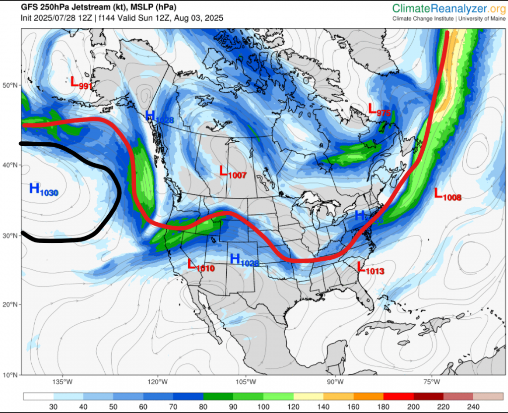
A strong blocking high is currently reinforcing itself over the southern US. Last time this happened we had a heat wave, but the blocking high didn’t stay for long. This time, it’s staying for weeks. Does this mean a big July 2024-esque heat wave?

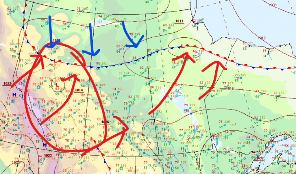
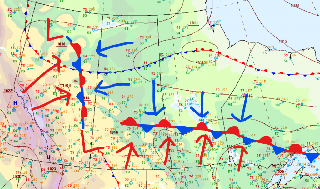
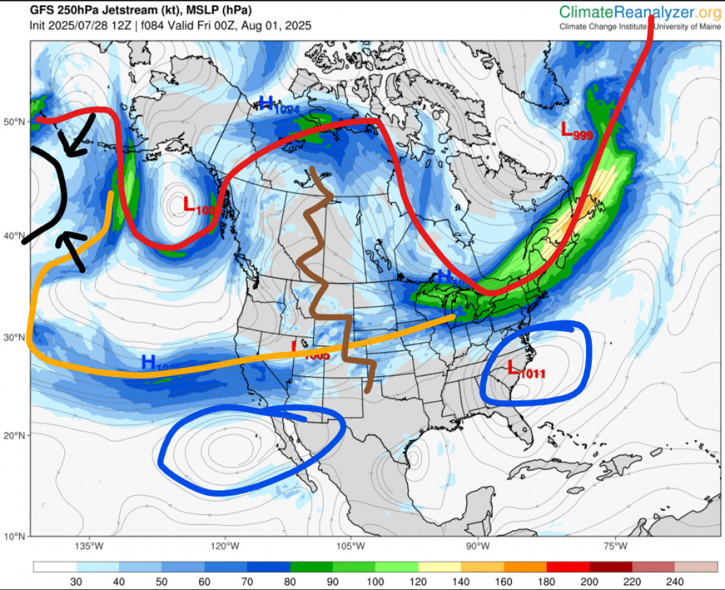
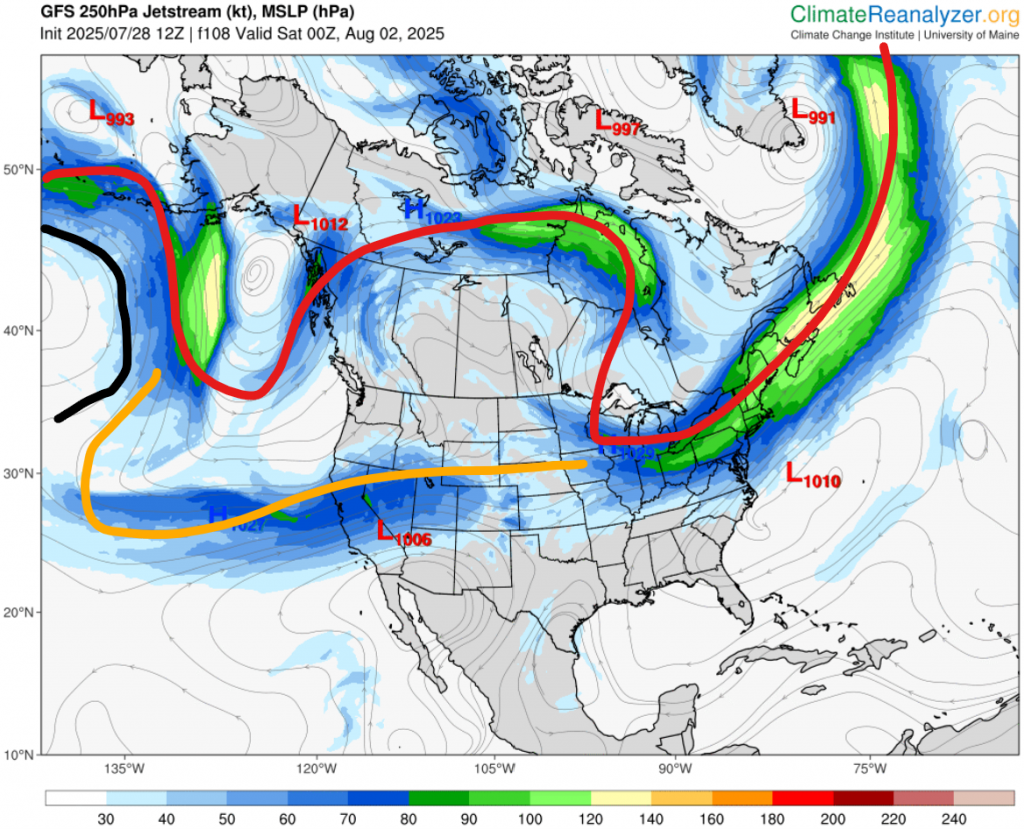
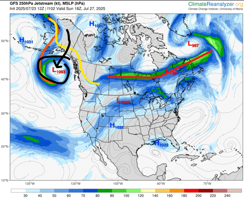
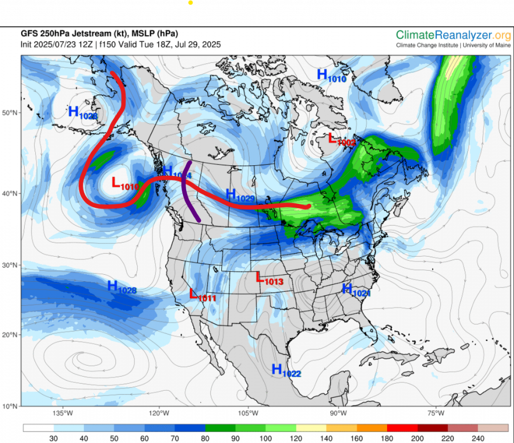
I am back to the blog, and it’s about time for a medium-range forecast. Over the next handful of days a pretty interesting pattern is about to take place over North America. A blocking high is reinforcing itself over the southern US, but more interestingly, a low is forming in the Gulf of Alaska, and is actually bringing an Atmospheric River to BC. You’ve probably heard the term “Atmospheric River” before, because they are a pretty common occurrence on the west coast. The only thing is: It’s August. Usually Atmospheric Rivers happen from October to December, but almost never August! So, if you look at the water vapor content in the north Pacific right now, it looks like winter. This high is going to try to ridge, but it’s actually still blocked by the whole rounds of lows we’ve been having. This means the jet stream is going to be stuck overhead until one side wins. Because the lows are still coming down, this means we’ll be near to slightly above normal temperatures, with continued shots of cooler air. Pretty much, this new pattern is going to end us up overall colder than the last one, since heat waves will be weaker.

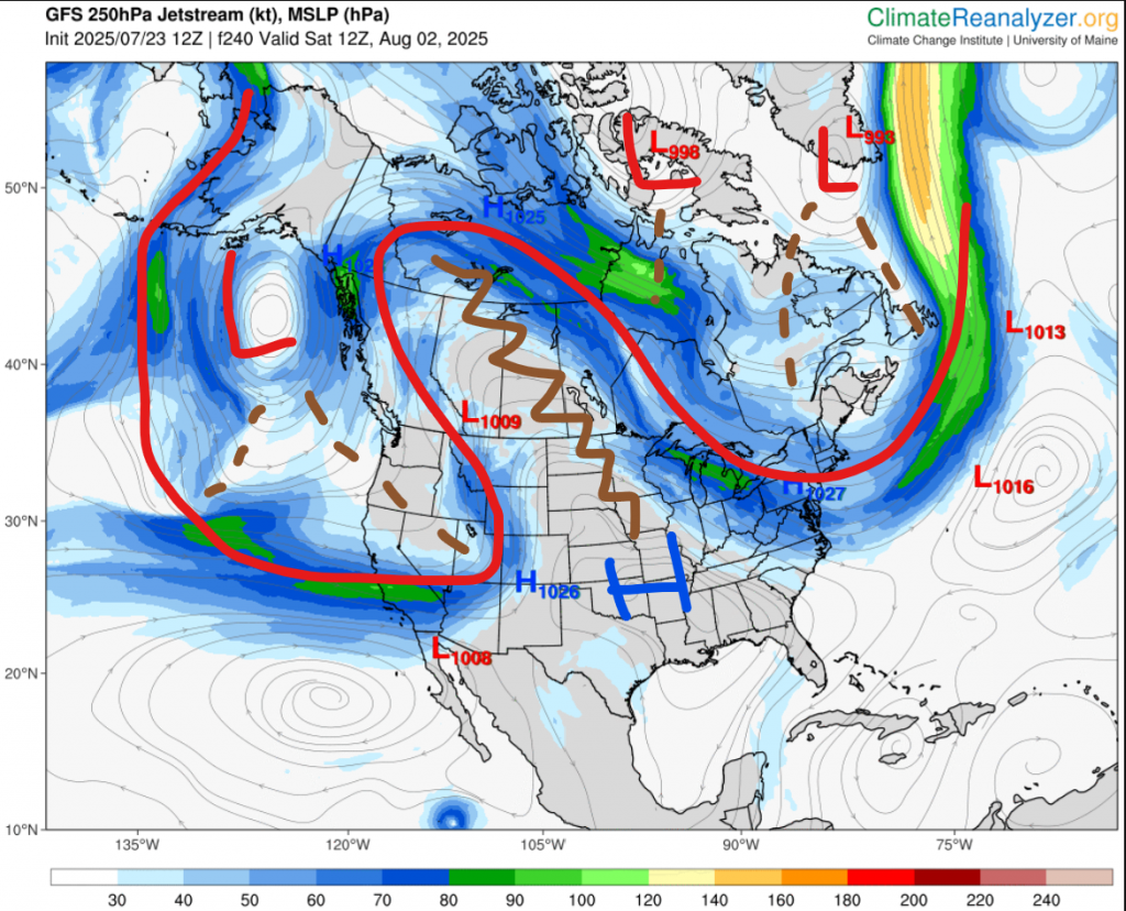
So now, here is your forecast: Heat wave Sunday through Tuesday, cold wave Wednesday through next weekend, Heat wave early the next week, and cold wave mid that week. That’s it for now. More updates next week.

Posted in Forecast, Temperature | Leave a comment

The long-overdue July recap is finally here!

We’re already over halfway through August, but I still haven’t done a July recap. Now is finally time.

The really big story through the whole month was the pattern. This pattern was pretty much a blocking high is the southern US trying so desperately hard to give us a heat wave, while a total of 7 lows laughed it is profusely. The jet stream for probably over half of the month was overhead, meaning also has lots of storms. So, parts of the city got more rain than June, but the actual place where the official Environment Canada station is, Blatchford, only got 36.8 mm. Also, around the end of the month we did see a short omega block appearance, which broke up the pattern for only a few days, before it came back.

Here are some stats for the month:

ValueCompared to last 5 yearsCompared to last 30 years
TemperatureMean 18.1 Highest 31.9 Lowest 5.61.5 degrees below0.25 degrees below
Precipitation36.8 mmNear normalNear normal
HumidityMean 60% Highest 99% Lowest 23%
Dew pointMean 9.4 Highest 16.2 Lowest -0.22.75 degrees below1.5 degrees below
HumidexHighest 35
WindMean 8.6 Highest 25 Lowest 0Near normalNear normal
GustsHighest 46
SmokeMedian ~45 AQI, 2.1 AQHI
MoistureMean ~20 kg/m²~2.5 kg/m² belowNear normal
Cloud coverMean ~60%~8% above~8% above
PressureMean 1015.4 Highest 1028.3 Lowest 999.3~1.5 hPa above~2 hPa above

Here are a few more stats:

  • Number of days with precipitation >0.2 mm – 11
  • Number of days with precipitation >25 mm – 0
  • Number of days with temperature <-20°C – 0
  • Number of days with temperature <0°C – 0
  • Number of days with temperature >30°C – 3
  • Number of days with humidex >30°C – 6
  • Number of days with humidex >35°C – 1
  • Number of days with humidex >40°C – 0
  • Number of days with wind chill <-30°C – 0
  • Number of days with wind chill <-35°C – 0
  • Number of days with wind chill <-40°C – 0
  • Number of days with AQHI >4 – 9
  • Number of days with AQHI >7 – 2
  • Number of days with AuroraWatch yellow alert: 6
  • Number of days with AuroraWatch red alert: 3

Well, there you go. August recap coming hopefully in the first half of September!

Posted in Aurora, Past weather, Precipitation, Smoke, Temperature, Wind | Leave a comment

Have we already seen our last 30 degrees of 2025?

With it only being early August, and quite an anomaly of the last four summers, it much more likely than you would think!

The main reason I’m writing this is the pattern. Oh, the pattern. The pattern we’ve had since June, where highs try so desperately hard to create a ridge, before being completely swept away by round of lows coming all the way from the Bering Sea, bringing temperatures down to high-teen highs, and sub-double-digit lows; along with some rain and thunderstorms. Going into even September, this pattern shows no signs of stopping.

Well, let’s take a look at pretty much our whole weather overview in the next month is right now. Currently, we our in some cold. Not very much, but not too little. It seems we’ll be back to mid 20 highs on Saturday. For Saturday through maybe Monday maybe Tuesday, temperatures will be slightly above average. Sort of 24 to 28ish. I really don’t think we’ll get 30 degrees; Environment Canada says 27 for Tuesday, and AccuWeather 26; but it still may happen. After that, Tuesday/Wednesday all the way to the end of next week, we are set for a cold wave. Early next week, sort of 17th to 19th, I do see another heat wave potential, but it seems another through is going to some through starting around the 20th. Once we get past the 20th, it gets pretty uncertain. The models really aren’t sure where and when the troughs will come through, so pretty much after 14 days ahead they just get really washed out. This is what they’ve been doing this whole summer.

Now we have to talk about AccuWeather. I think I’ve mentioned this once or twice here before, but AccuWeather has a 3-month daily forecast. Past 10-14 days, the forecast isn’t great there, but not horrible. Around a month ahead, It actually gets really bad. I’ve noticed it usually ends up being the opposite. But, for some reason, I have no idea why, but for 5-6 weeks ahead its accuracy goes up. I just want to mention it, but it seems, based on this, the pattern will probably continue into September. After 6 weeks ahead, it get really bad again, but you can’t blame it. That’s basically impossible to predict.

In all, I would say the probability of us not seeing any 30 degrees for the rest of 2025 is 30-60%

One last thing; next week I am going to day camp. It is from 9 am to 5 pm (I think) each day for the whole 5 days. This means there will be no evening forecasts, and probably no posts on the blog as well.

Posted in Uncategorized | Leave a comment

Showers and storms today through Friday

Rain and thunderstorms will move through the area over the next 60ish hours. Accumulation will vary, but is expected to reach 10+ mm.

Starting off today, we may see some possibly severe thunderstorms this afternoon or evening. A low is currently developing over south-central Alberta, and will bring some slow-moving thunderstorms. Tonight, some rain will position itself near Hwy 16 west of Vegreville. This rain will be moderately heavy, and will continue through tomorrow morning. Overnight tonight, we can’t rule out a surprise thunderstorm. During the day tomorrow, it seems the precipitation will arrange into some wrap-around, as the low causing all this moves into central Saskatchewan. This wrap-around precipitation will stem from near Battleford, go up to Slave Lake, then down around to Drayton Valley or Rocky Mountain House. This does seem it will slow down rain here a bit, meaning we may only see a few showers tomorrow night. On Friday as the low continues eastward, we will see the wrap-around rain come to us, with some possible imbedded thunderstorms. The precipitation is expected to be over by Saturday morning.

So, how much accumulation are we talking? I would say we’ll have a baseline of ~10 mm. That is from the rain after tonight. How much we actually get though heavily depends on if we get hit by storms. If we don’t, 8-15 mm it is. If we instead get hit by a severe thunderstorm today, and another storm on Friday, then we could see well above 50 mm. It really depends on where the storms are.

One more thing; temperatures. Today is 27 (probably), tomorrow near to slightly below 20, and Friday a few degrees above that. After that, we are expected to return to mid 20 highs for the weekend and early next week.

Posted in Forecast, Precipitation, Temperature | Leave a comment

This week’s forecast: A whole lot of CCC

At the moment, the jet stream is kind of all over the place. Roughly though, it’s overhead-ish.

As we look into the week, we can see lots of storm potential. In fact, every single day for the rest of this week probably has an >30% chance of us getting a thunderstorm. This is because of the same reasons of all other stormy days we’ve had in the last month or two. We have warm and cold air mixing together and creating instability, a close jet stream, and no blocking patterns.

A thing that will be paired with the storms this week is more low 20 highs, like a lot of what has happened so far this summer. The ridge will move eastward, and a through will come in its wake. It has already appeared in northern BC, and will dig its way down all the way to Montana this week, and will likely cool temperature down by about 5 degrees, starting Wednesday. The low will also bring clouds, so the second half of the week, mainly Thursday and Friday, will see semi-overcast skies.

Now what about precipitation? Just like what we had over the weekend, most of it is going to be from storms. This means precipitation will be very variable, just like how in the last 48 hours Stony Plain got over 20 mm, while my house probably got about 1.

That is it for today. If you want more details, just wait for my email forecast this evening. If I end up busy, then maybe tomorrow evening.

Posted in Forecast, Precipitation, Temperature | Leave a comment

Great severe thunderstorm potential tomorrow into tomorrow night

Tomorrow afternoon, evening, and overnight; we will have very good chances at severe thunderstorms. Today, we have a chance at a thundershower, though it isn’t really too much of a chance. We might only get a quick shower this evening, if anything. As we look towards tomorrow though, instability will become way way higher. Here is a surface analysis chart with some overlaid stuff I’ve out on it. It is from noon today.

As you can see, we have low pressure over Alberta (the red circle), as well as a very long frost going off the the east. The red arrows are warm air, and the blue arrows are cold air. If you know anything about what causes storms, you would know they need instability in the atmosphere, and the usual cause for this is a clash of warm and cold air. So as you can probably infer, the area around the stationary front in northern Alberta is where we’ll see the most storms today. The most common cause for storms here is warm air flowing over the Rockies, which causes lots of instability and storms generating in foothills before moving off through the prairies. It might seems like that is happening here, but there’s one problem. For the storms to actually move anywhere, they need the help of the jet stream. Currently it’s tied up in being a ridge right now, so the storms can’t move eastward. This means we probably won’t see any storms today, maybe only if a local cumulonimbus pops up.

Next, here’s what is expected for tomorrow at noon, overlaid with the same map:

As you can see now, we have mainly two lows, with lots of warm and cold air mixing over central and southern Alberta, central and southern Saskatchewan, and southern Manitoba. The low we’ll be looking at is the southern one. Around here, there will be lots of moisture, meaning on mostly the northern side (because that’s where the stationary front is) there are very good conditions for severe thunderstorms. This low is actually going to move northward very slowly through the day and night on Sunday, meaning from mid afternoon tomorrow to overnight tomorrow night, we have a quite prolonged chance for severe thunderstorms.

In wake of this, starting on Monday, we will probably see good chances for thunderstorms every single day next week, since the jet stream will be near and instability holds.

Posted in Forecast, Precipitation | Leave a comment

August forecast: Will the pattern continue?

It’s a new month! Here’s what it may look like, divided into 5 sections:

PART 1 (1st – 2nd)

This part consists of today and tomorrow. As you probably know, these two days will be the final days of a heat wave we’ve had for a little while now. Highs will probably be right around 30.

PART 2 (3rd – 9th)

It seems after Saturday we will return to normal temperatures, but far from quietly. From Saturday night to Monday, showers and many storms are expected. After that, it seems thundershowers will probably continue as temperature follow a slow cooling trend down to below average. This is caused by the jet stream being near overhead as the ridge we have now will depart to the east.

PART 3 (10th – 13th)

It seems around here we might see a short heat wave as an upper-level high pushes up from the US, cause some ridging.

PART 4 (14th – 20th)

After the heat wave, we’ll probably once again go into our CCC state, but afterwards is when it gets a little fuzzy. It seems one of two things will happen. Either we stick with our pattern of alternating short-lived heat and cold waves, along with frequent storms; or we might end up in a drier and (maybe?) warmer anomaly. Currently it is hard to tell.

PART 5 (21st – 31st)

Here is where the most uncertainty is, as can be expected. This part may end up being pretty below average, though that’s not for certain. Near the end, there is a pretty good chance for a larger heat wave, which may continue (but more likely start) in the beginning of September.

Now, here are some things to expect for the month as a whole. For temperatures, we’ll probably end up near normal overall. For wind, it’ll probably be the same as July: Calm some days, windy most days. In terms of precipitation, there will very likely be a lot of variation, depending on where storms hit. Some parts could see only 30 or so mm for the whole month, while area only a handful of kilometres away could see well over 100. Finally, for smoke, I don’t think we are going to see too much. The areas where we usually source our smoke (northern Alberta and southern NT) look like they will get lots of rain.

One more thing, about the July recap, that will come sometime soon, but not today. It turns out the websites I use need a few days to collect all the data from the models.

Posted in Forecast, Precipitation, Smoke, Temperature, Wind | Leave a comment

Heat wave update: It’s much shorter than we thought

Back on Wednesday, I said that there was a possible larger heat wave coming this week into next week. So, this week is this week, meaning it’s time for an update.

For the next few days, not much has changed since then. We still have the low sneaking its way into the Gulf of Alaska. We still have a blocking high in the southern US which is ridging up to here. The main thing that has changed is what happens after Thursday.

First of all, let’s look at Thursday evening, which is the first picture. I have laid out where the polar jet stream and subtropical jet streams are. You can see the classic omega block pattern. At this time we have not one, but two blocking highs below the subtropical jet stream, which are collectively enforcing a ridge (zigzag line) up to Alberta. What I really want you to take notice to though is the Pacific high. That is the one on the left with the arrows pointing to it. Now, look at the second picture. This one is for just 24 hours later. Notice anything different about the Pacific high? Yes, that’s right. It’s expanding to the west. If you go to the third image, this time on Sunday morning, you can see the jet stream has gone way south and we are now in a cold wave.

Next, let’s move to what the actual temperatures may look like during the heat wave.

Expected highExpected low
Monday~20Low teens
TuesdayMid 20sMid teens
WednesdayHigh 20sMid to high teens
Thursday~30High teens
Friday~30Mid teens
SaturdayLow to mid 20sMid teens

Finally, precipitation. Besides today, the work week looks bone dry. Only when we get to Friday night there are some possible showers and/or storms.

If you want to know what next week and beyond will be like, then you won’t have to wait long! I will post an August outlook later this week.

Posted in Forecast, Precipitation, Temperature | Leave a comment

Another wave of CCC weather this weekend!

This weekend because of low pressure and the western side of some zonal jet stream flow over the area will cause temperatures about 4 degrees below normal, partly cloudy to overcast skies, some scattered showers, and we can’t rule out some isolated thundershowers.

So, how much rain are we thinking? I would say probably something like 5-10 mm. Maybe more though. A lot of this is hit-or-miss showers, so it is possible we only get something like 3 mm, but also just as possible that someplace in the city gets 20. For the timing, I would say we’ll probably start with some showers or thundershowers in the afternoon/evening on Saturday, followed by some showers continuing into Sunday. Which should be over by Sunday evening.

Posted in Forecast, Precipitation, Temperature | Leave a comment

A heat wave could be on the horizon…

The following material may contain many terms you are unfamiliar with. This time, I’ll just let you look it up.

We’ve been very lacking in the heat wave department so far this summer, but it looks like pretty late in the omega block season, we may actually get something. Let’s take a look at our upper air forecasts. Here I will supply a “gallery” of images for you, to reference as I explain what’s going on. If you want to see the images better, right click them, and then press “Open image in new tab”.

First image: This is the forecast for Sunday. You can see there is a long area of zonal flow (red line). If you didn’t know with zonal flow usually is it sunny near the eastern edge, but then as you slowly go west, it gets cloudier and cloudier to point where there is rain near the western edge. As you can see, we are going to be on the western edge, and this might bring some rain on Saturday night into Sunday. The main thing to look at here though is the low in the Gulf of Alaska. As I have mentioned many times, whatever is going on in the Gulf of Alaska really controls what happens here. A high, low temperatures. A low, high temperatures. This area has been dominated almost entirely by the Pacific high this month, which is why we’ve been so cold. But, as you can see, there is a low there on the map. This low is currently forming in Alaska, and is expected to move south, before stalling in the Gulf of Alaska. The orange line is the jet stream then, and the yellow is the jet stream now.

Second image: This one is for Tuesday. Now the low is almost a cut-off low. It has caused significant troughing, which has made way for a blocking high in the southern US to start to ridge up north. This could be the beginning of a heat wave.

Third image: Now we’re at the start of the first weekend of August. The jet stream made its way all the way down to the subtropical jet, the high has ridged up more, and some lows around Baffin Island and the southern tip of Greenland has also started to trough. This means we have a full omega block.

Now, we must ask, how long will this stay? Well, here’s the interesting thing: It seems the shortwave trough in the third image that is pushing southeast of the westerly low may actually push the blocking high far enough to displace it to be more centred around Florida, which may give the jet stream wiggle room to jump the Rockies at least temporarily. Forecasts have been suggesting a cooldown around the first or second day of the month, but aren’t really sure what’s going to happen after that. Some say the heat will return for another 5 days or so, but others say the omega block may move farther to the east and we’ll suddenly be in a cold pattern. Right now, it’s hard to say who’ll be correct.

For now, that’s where I’ll leave it. I’ll post a short-range forecast on probably Monday, explaining for about what next week could shape up to be.

Posted in Forecast, Precipitation, Temperature | 1 Comment