
A really big weather flip is on it’s way, which will set the weather tone for the rest of spring break. Here’s what’s going on:
If you have taken a look at a forecast lately, you probably would have noticed the temperatures are about to drop way down to near 0 highs. Well, what’s the reason for this? Mainly, it is three pressure systems tangling the jet stream in just the right way for an extended cold wave. Here’s a picture to explain what’s going on:
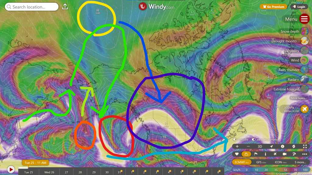
The map here shows what the wind is like right now 9 km above us. The yellow line shows where the jet stream is right now.
I have on the map our three pressure systems marked out. There is a low in the Gulf of Alaska (Red), a high to the west of that low (Orange), and a high near the north pole (Yellow). The high in the Pacific Ocean will move northward (Lime), and push up the jet stream (Green). The big thing that will cause the cooldown is the second high, which is in the polar vortex, moving down towards the land (Blue). It is moving because it was pushed away by the first high moving northward and causing the jet stream to ridge. As this high moves down, it will push the jet stream south creating an area of zonal flow (Light blue), which doesn’t really matter to us as it’s in the southern US. However, what does matter is that the high has moved down south to the Canadian prairies, and will be giving our area a period of cool weather (Dark blue).
Well, looks like we’ll be in for a ride with all the water freezing up again. Luckily, it doesn’t look like we’ll get any precipiiwwait a minute! You thought it was over? Try reading the next post! This one was only part 1!