
Yay, another post! This one is for quite a significant event incoming; the return of winter. For the last several weeks, warmth has dominated. It was quite a change after all the chaos that ravaged us in December, but now it seems we might be returning to that.
Before I get into the timing of the precipitation, here’s a 500 hPa map for right now:
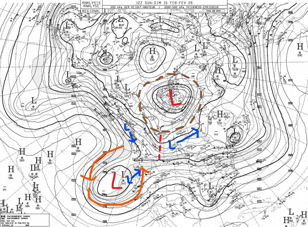
I have two major upper lows (red) marked in this picture; one in the Arctic and one in the Pacific. The Arctic one is currently the most dominant polar vortex lobe on Earth right now, and has been bringing some absurd stuff like below -60 wind chills to some communities. That was not a typo. It has a bit of a trough, which has been the source of our slightly cooler temperatures yesterday and today, but the main product of this trough has been some light snows in SK/MB. Those are associated with a surface low (which I have marked in blue) currently moving quite quickly to the east.
The other major upper low is a cut-off low off the Californian coast. Flow around it is marked in orange. The last two lows on this picture are other surface lows, which are moving in the direction of their arrows, but not very fast.
If you haven’t read the previous post yet, I would much suggest doing that now. You can see the pattern change that I described there getting ready to occur in this image; the big upper high there in the Pacific has a ridge going upwards, with some lows to the left. Those very lows, specifically the more southern one, are the ones that will push the ridge way up to Alaska, causing the reflection over the west coast of North America.
The low in blue currently on the southern Alaskan coast will be the one attached to the soon-to-descend upper low. As this low moves south, the upper-level flow will merge with the cut-off low, while the southbound surface low will instead push the existing one already there off to the northwest. Know what else is to the northwest? Us.
Now that you know the setup, let’s play out what will happen:
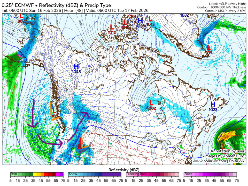
The first image shows midnight on Monday night. The low on the coast is descending, while the one that was way down south is now all the way at Montana. With these two systems so close, which one’s wind field will dominate? The answer is the one on the coast for near the surface, because it doesn’t have as many mountains in the way of it. Once you get above the mountains though the separation will roughly get to the middle. This means three key things: One, the cloud will be carried way up from the Pacific, meaning it has a lot of moisture, so the cold air will cause a lot of condensation and then precipitation; two, there will be a lot of wind shear increasing instability and thus further increasing precipitation intensity; and three, the cloud, though still attached mainly to the Montana low, will be pushed northward by the other low, meaning precipitation will later be as far as over 1000 km north of the actual low, meaning the low is in the US while precipitation is touching the NWT.
As you can see in the first image, snow as already started for us. It will probably begin sometime in the afternoon tomorrow, most likely later in that time frame, before quickly intensifying.
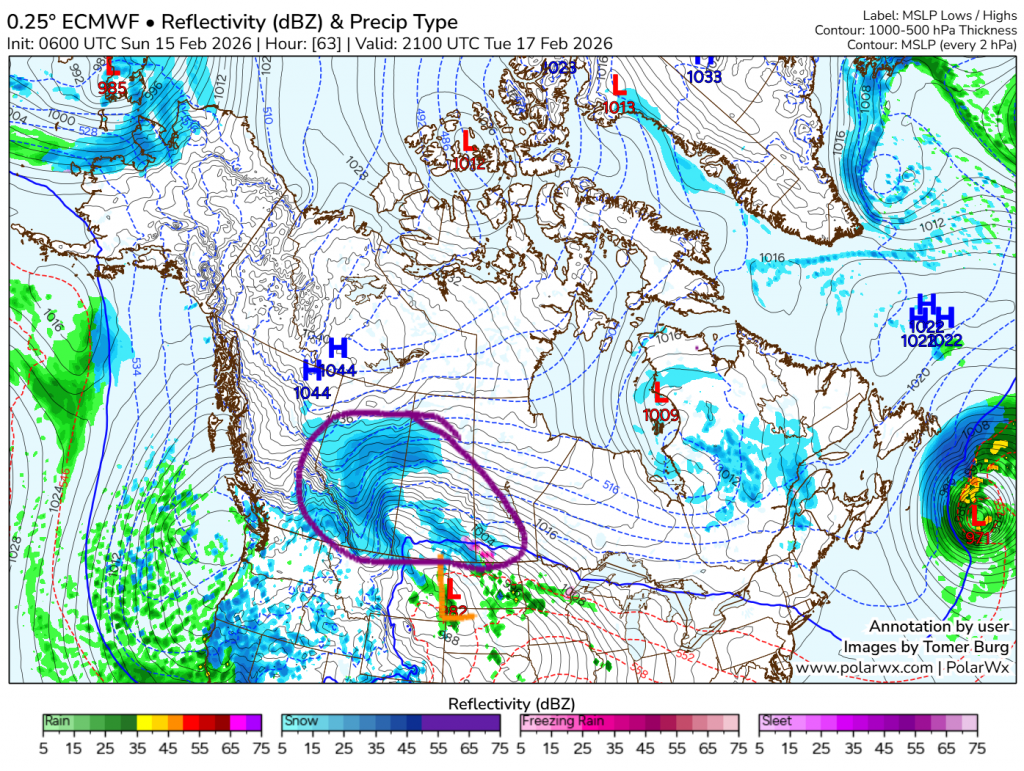
The next image skips ahead all the way to mid-afternoon on Tuesday. The low barely moved, while the snow now engulfs most of Alberta and areas of Saskatchewan. Heavy snow has not really stopped at all for nearly 24 hours.
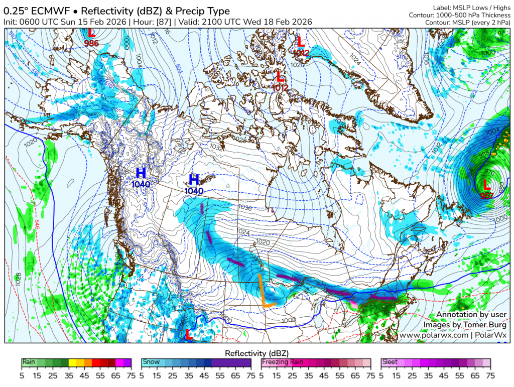
The third and final image is another 24 hours after the second. By this point snow has stopped, but it doesn’t really seem like it has for very long.
So now, what are our accumulations? For the southern three quarters of the province, most forecasts are somewhere in the 10-20 cm range. There is the possibility of local accumulations getting up to 30 cm basically anywhere in this area, depending on what model you decide to look at. There is also a risk of blowing snow for Alberta, though mainly south and east of here. There might be some mild blowing snow for us, but mainly it will just be pretty drifty, and definitely not a blizzard.
What about temperatures? It seems they will be declining at some rate from Tuesday afternoon to Wednesday morning. Tomorrow will have a high somewhere around -5, and -20 is likely to be reached on Wednesday. I will have out a more detained post on the temperature in a few days’ time.
So there you have it. This snow is probably going to be very disruptive, so be prepared for some travelling troubles on Tuesday and Wednesday, before the snow starts to get cleared. Goodbye, and happy shovelling!