
Over the next 7 days, many showers and storms are set to pass through, and it looks like it will total all the way up to 50 mm of precipitation. For reference, that about as much as we got in all of September, October, and November combined.
So, how is this expected to play out? Well:
MONDAY
We will start off with today. During the actual day, nothing has really fallen, but tonight we might see some action. Overnight, it seems like a thunderstorm will pass through, bringing a widespread 1 mm, but much higher amounts, like 10 mm, in certain places. For our 50 mm, I am just using the widespread amount, which means if you (or rather your plants) are lucky, you may even see well over double that amount.
TUESDAY
For all of the day and night tomorrow, there is a chance of showers or thunderstorms. We are most likely to get some in the evening. A few widespread millimetres, but of course higher amounts where the strong cells hit.
WEDNESDAY
On Wednesday, thundershowers could show up anytime from sunrise to sunset, with showers possibly prevailing through the night. Here the areas that storms have missed so far look like they’ll get a treatment of 5-10 mm.
THURSDAY
Thursday looks like quite a bit of rain and maybe thunderstorms as well during the day, and some lingering showers into the night. Overall 10-15 mm of rain. That’s quite a lot!
FRIDAY
On Friday, MORE thundershowers in the day, and steadier rain in the night, totalling 5-10 mm of rain.
SATURDAY
Showers throughout the day and night, but finally a break from thunderstorms. Another 10-15 mm.
SUNDAY
Though not in this week, Sunday is expected to be sort of a continuation of Saturday, with an extra 5 mm.
So overall, we are supposed to get pretty much non-stop periods of rain, showers, thundershowers, and thunderstorms for the next 7 days, totalling to 50 mm. Now that’s a lot of rain.
Also, here’s the expected total rainfall for the next 7 days on a map:
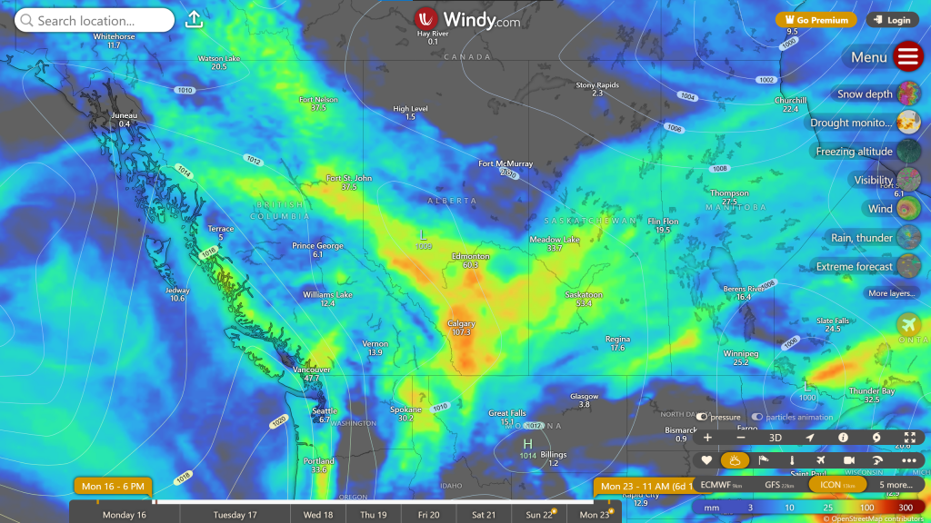
You can see that this is not just local. Lots of Alberta and Saskatchewan are getting similar things to us.